




 Click to Search
Search
{{#data.error.root_cause}}
{{/data.error}}
{{^data.error}}
[{{{type}}}] {{{reason}}}
{{/data.error.root_cause}}
{{#data.hits.hits}}
{{#_source.featured}}
FEATURED
{{/_source.featured}}
{{#_source.showImage}}
{{#_source.image}}
 {{/_source.image}}
{{/_source.showImage}}
{{/_source.image}}
{{/_source.showImage}}
{{/data.hits.hits}}
{{{_source.title}}} {{#_source.showPrice}} {{{_source.displayPrice}}} {{/_source.showPrice}}
{{#_source.showLink}} {{/_source.showLink}} {{#_source.showDate}}{{{_source.displayDate}}}
{{/_source.showDate}}{{{_source.description}}}
{{#_source.additionalInfo}}{{#_source.additionalFields}} {{#title}} {{{label}}}: {{{title}}} {{/title}} {{/_source.additionalFields}}
{{/_source.additionalInfo}}


Latest News










Subscribe to the Update
- Category: Weather
ROAD ADVISORY
Difficult Driving Conditions – Virden Area
Difficult Driving Conditions, NM 92 eastbound and westbound from mile marker 0, Arizona State Line to mile marker 6, 3 miles east of Virden. Low water crossing are running water. Crews will continue to monitor and clear debris as needed. Standing water on roadway. Use extreme caution.
- Category: Front Page News
The New Mexico Department of Transportation (NMDOT) has developed a final design for improvements along US 180, NM 90, and 14th Street In Silver City.
See flyer below with information and key points
- Category: Weather
Detour for I10 eastbound traffic has been removed in Arizona. Removed closures and alert from NM Roads.
ROAD ADVISORY:
ROAD CLOSURE – Arizona Stateline Area
Closure, I-10 eastbound lanes from Arizona into New Mexico are closed at the Stateline. All eastbound traffic is detoured at AZ SR 191 to US 70 into Lordsburg. Use caution of heavy congestion from the US 70 Arizona Stateline into Lordsburg.
- Category: Weather
ROAD ADVISORY
CLOSURE – Lordsburg Area
Closure, NM 92 eastbound and westbound from mile marker 0, Arizona State Line to mile marker 6, 3 miles east of Virden is closed due to flooding. Roadways are not passable. Do not attempt to cross. The NMDOT is currently clearing roadway and will notify as conditions change.
When the roadway is flooded do not cross and seek an alternate route. Turn around, don't drown.
- Category: Front Page News
By Roger Lanse
Grant County Sheriff's Office deputies responded Monday, Aug. 3, 2026, at approximately 3:15 p.m., to a crash involving two vehicles, a Lincoln sedan and a UPS delivery truck. GCSO staff told the Beat the crash occurred on Highway 180 near Arenas Valley Road (MM119), and resulted in injuries. At least one person was transported to Gila Regional Medical Center.
New Mexico State Police officers assisted in the incident. A more complete accident report from the GCSO is forthcoming.
- Category: Front Page News
By Frost McGahey, Investigative journalist
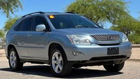 Stock Photo from CarGurus
Recently Ann, a reader of the Grant County Beat, described how after a minor fender bender, Liberty Mutual declared her 2005 Lexus SUV a total loss. It shocked her since the car was drivable and had only sustained damage to the passenger side doors and the rear bumper.
The Liberty adjustor said the car was worth $5000, and it would cost $4500 to repair which made it for the company a total loss. This shocked Ann.
Page 10 of 76





Content on the Beat
WARNING: All articles and photos with a byline or photo credit are copyrighted to the author or photographer. You may not use any information found within the articles without asking permission AND giving attribution to the source. Photos can be requested and may incur a nominal fee for use personally or commercially.
Disclaimer: If you find errors in articles not written by the Beat team but sent to us from other content providers, please contact the writer, not the Beat. For example, obituaries are always provided by the funeral home or a family member. We can fix errors, but please give details on where the error is so we can find it. News releases from government and non-profit entities are posted generally without change, except for legal notices, which incur a small charge.
NOTE: If an article does not have a byline, it was written by someone not affiliated with the Beat and then sent to the Beat for posting.
Images: We have received complaints about large images blocking parts of other articles. If you encounter this problem, click on the title of the article you want to read and it will take you to that article's page, which shows only that article without any intruders.
New Columnists: The Beat continues to bring you new columnists. And check out the old faithfuls who continue to provide content.
Newsletter: If you opt in to the Join GCB Three Times Weekly Updates option above this to the right, you will be subscribed to email notifications with links to recently posted articles.
Editor's Notes
It has come to this editor's attention that people are sending information to the Grant County Beat Facebook page. Please be aware that the editor does not regularly monitor the page. If you have items you want to send to the editor, please send them to editor@grantcountybeat.com. Thanks!
Here for YOU: Consider the Beat your DAILY newspaper for up-to-date information about Grant County. It's at your fingertips! One Click to Local News. Thanks for your support for and your readership of Grant County's online news source—www.grantcountybeat.com
Feel free to notify editor@grantcountybeat.com if you notice any technical problems on the site. Your convenience is my desire for the Beat. The Beat totally appreciates its readers and subscribers!
Compliance: Because you are an esteemed member of The Grant County Beat readership, be assured that we at the Beat continue to do everything we can to be in full compliance with GDPR and pertinent US law, so that the information you have chosen to give to us cannot be compromised.
Submitting to the Beat
Those new to providing news releases to the Beat are asked to please check out submission guidelines at https://www.grantcountybeat.com/about/submissions. They are for your information to make life easier on the readers, as well as for the editor.
Advertising: Don't forget to tell advertisers that you saw their ads on the Beat.
Classifieds: We have changed Classifieds to a simpler option. Check periodically to see if any new ones have popped up. Send your information to editor@grantcountybeat.com and we will post it as soon as we can. Instructions and prices are on the page.